


El Niño Is Coming in Hot: What the 2026-27 Ski Season Could Look Like Across North America
If you skied out West last winter, you probably want to forget it. Utah got so warm at times that resorts couldn't even make snow. So it's no surprise that people are grasping at straws for this season. My social feeds are full of it: moose and bear videos "proving" the animals are fattening up for a big winter, and folks in Idaho swearing the mullein is growing extra tall.
To get the real deal I brought back one of our favorite guests, Alan Smith, meteorologist and operations manager at OpenSnow. Alan is based in Jackson, Wyoming, and he specializes in mountain weather forecasting. OpenSnow just released its winter outlook, and the headline is a big one: we're heading into what could be a record-setting El Niño.
First, a Reality Check
This is a seasonal outlook, not a forecast. Nobody can tell you it's going to dump in Revelstoke in mid-January. As Alan put it, outlooks are "just tipping the odds one way or another. It's not a guarantee." They're based on how similar winters have played out historically.
Mother Nature always gets a say. Keep that in mind as you read on.
El Niño
El Niño is all about ocean temperatures in the eastern and equatorial Pacific. When the water there runs warmer than average, that's El Niño. When it's cooler than average, that's La Niña, which is what we had last winter (a weak one). This year, the water isn't just warm. According to Alan, it's "pretty close to record levels" above average. That's why this El Niño is getting so much hype. It does two big things to winter. First, it shifts the storm track. El Niño powers up the subtropical jet stream, which tends to push storms farther south. Second, it affects temperature. That faster west-to-east flow makes it harder for Arctic air to drop into the lower 48, so much of North America tends to run warmer. Alan has noticed that recent strong El Niños have been notably warmer than strong El Niños from 25-plus years ago. So while he expects a more active storm track across the West than last winter, temperature is the wild card. It's the difference between a five-foot dump and a rainy weekend.
One more term you'll hear: a trough. Alan describes the jet stream as a conveyor belt that dips and rises around the planet. A dip, or trough, brings colder air and energy that spins up storms. A rise, or ridge, brings high pressure and warm, dry weather. OpenSnow also looked at the QBO (a pattern of upper-level tropical winds), which is heading into a westerly phase. That tends to favor more troughs over the West. Good news for powder.
Region by Region
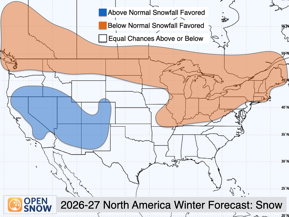
Western Canada: a tougher year. Last winter, the eastern Canadian Rockies (Lake Louise, Banff, Kicking Horse) were a true anomaly, with lots of storms and cold enough temps to avoid rain. Lower spots like Whistler, Fernie and Whitewater weren't so lucky. This winter, El Niño's strongest warm signal sits over the Pacific Northwest and western Canada. Precipitation looks about normal along the Coast Range near Whistler, but Alan sees a below-average snowfall signal for most of western Canada. Warmer temps mean higher snow levels, and inland areas like Revelstoke, Kicking Horse and Banff tend to run drier in El Niño years.
Northern Rockies and Colorado: could go either way. For the Tetons, Idaho and northern Colorado, there's no strong signal. Past winters like this one in Jackson have mostly landed close to average. Summit County, Aspen, Crested Butte and Steamboat have been more boom or bust. OpenSnow calls this "equal chances," and Alan was careful to point out that's not the same as "average." It just means it could swing either way.
California: above-average snow favored. The Sierra gets one of the best signals on the map. Strong El Niño plus that westerly QBO point toward an active storm track and above-average snowfall. The catch is temperature. Alan says one storm could bring a massive five-foot dump all the way to the base, and the next could ride in on a subtropical plume that pushes snow levels near the summits. That's rain at the base, and it often comes down to just a couple of degrees.
Utah: payback time? Utah got robbed last year, and the outlook is friendlier this time. Alan sees an above-average snowfall signal similar to California's, but with an above-average temperature signal too. Remember those storms last year that brought wet snow or rain to Park City? That risk hasn't gone away. Still, overall it's a more favorable outlook than last season.
The Southwest: reason for optimism. This is the sweet spot for strong El Niño winters. Think the San Juans, Brian Head, Arizona Snowbowl and Taos. The subtropical jet steers storms farther south, and sometimes a "cutoff low" parks over the Four Corners and slowly spins. Those can be hit or miss, but when they line up, they unload. They also tend to make their own cold air, and with peaks reaching 11,000 to 13,000 feet, elevation helps too. Alan also noted these storms are more common early and late in the season. Keep an eye on November-December and March-April.
The East: meh. New England had a great season last year, but El Niño brings a pretty clear warm signal to the East. Add it all up and Alan sees below-average snowfall for most New England resorts. Further south, a big nor'easter can still clobber West Virginia, Virginia or North Carolina if the cold air and a coastal storm line up. But Alan says that's less likely these days with warmer El Niños. Look at past strong El Niño winters: in 2015-16, Washington, D.C. got a 30-inch snowstorm and almost nothing else all season, and in 2023-24, a lot of mid-Atlantic and Northeast cities saw no snow at all.
The Upper Midwest: maybe skip it. I asked if it's a bad year for Boyne. Alan agreed that strong El Niños correlate poorly with snow in the upper Midwest and Great Lakes. That region may have the strongest warm signal in North America.
The big picture? Alan says to picture the edges of the U.S. The West Coast, the southern tier and the East Coast show the strongest wet signals. The northern interior is either uncertain or drier.
Bonus: Europe and South America
El Niño's reach is weaker in Europe, but this one is so strong that it'll likely have some effect. OpenSnow's analysis points to above-average snow in the high Alps (Austria, Switzerland, Italy, France) but warmer temps too. If you're skiing low in the Alps, watch out for rain and a thin snowpack. The higher you go, the snowier it looks.
How to Actually Use This
"There's probably going to be parts of this forecast that end up being incorrect," he told me. "That's just the way it goes with seasonal forecasting." And a season's overall result doesn't tell you anything about your trip week. Colorado could have a below-average winter and still get slammed the one week in February you're there. Tahoe could have a monster season and you could land in a two-week dry spell. So the best advice hasn't changed. Stay flexible, and watch the forecast 10 to 14 days out. If you can move your trip when you see a storm lining up, you'll find good snow in almost any year.
The Bottom Line
A record-setting El Niño is on the way. The odds favor California, Utah and the Southwest, especially the San Juans and Taos. Western Canada, New England and the upper Midwest look tougher. The Tetons and Colorado are a coin flip. Everywhere, warm temperatures and high snow levels are the thing to watch.
As for Alan, he's hoping for at least an average winter in Jackson. "As long as we see notable improvement from last year, I'll be pretty happy." Same here. If you see him on the tram, catch him early.
Listen to the full conversation with Alan Smith on Where to Ski, wherever you get your podcasts. And before the snow flies, gear up at backcountry.com with code WHERETOSKI.
Thanks to Opensnow - you can find out more here

Episode Transcript
Welcome to Where to Ski, I'm John Morgan. Today we're taking a quick peek into the 26-27 trends in weather that might affect your skiing. In this episode, we're really looking mostly at North America, so if you're in Europe, we probably won't talk much about that or South America.
My guest today is Alan Smith. He's been with us before. He's awesome.
He's based in Jackson, Wyoming. He's the meteorologist and operations manager for OpenSnow, and he specializes in mountain weather forecasting. So after this quick break, we'll talk to Alan and get the real deal on what might happen this winter, snow-wise.
I always need new stuff, and I go to backcountry.com to get it. They have the best selection of ski gear and their gearheads check out every piece. They're hooking up Where to Ski listeners with a discount.
Just use code WHERETOSKI at checkout or hit the link on our website. That's backcountry.com. Alan, welcome back to Where to Ski. We're thrilled to have you here.
Thank you so much for having me, John. It's great to be back. Oh, well, we've got lots to talk about.
You know, people had a really miserable winter out west last year, and I think they're grasping at any straw they can to try and say, oh, it's going to be awesome this year. You know, if I go on socials, I'm getting hit with stuff like everything from people sending moose and bear videos saying, oh, they're eating to store up for a big winter, to people in Idaho saying the mullein's growing really tall. I mean, it's just crazy.
And like I said, I think people are grasping at straws a little bit more over the top than it has been for the past few years. Now, you guys at OpenSnow just put out a forecast around El Nino and what it might mean for this winter. Maybe we could start diving into that, maybe a little bit about what El Nino is without getting too technical.
Sure. So El Nino basically refers to sea surface temperature anomalies in the eastern and equatorial Pacific Ocean, and the El Nino phase occurs when the sea surface temperatures in this region are warmer than average. And this year, they are well above average.
In fact, pretty close to record levels of above average right now. And so that's why this El Nino is getting so much hype for this winter, because it's looking to be a record setting El Nino, just because the ocean is so much warmer than it usually is in this region. La Nina is the opposite in which the ocean temperature anomalies are below average in these regions.
We had that last year, right? We did. We did. We had a weak La Nina last season, meaning that the sea surface temperature anomalies were just a little bit below average, but not excessively so.
So I see sort of two parts to this conversation, and you correct me if I'm wrong. I'm no meteorologist. There's the storm movement and the pattern that the storms take, and then there's also temperature.
You know, I remember last year, I'm thinking Utah specifically, it got so warm they couldn't even make snow. Yeah, it's definitely multifaceted. I mean, you're looking at it's favoring different types of jet stream patterns, storm tracks, but temperature plays a big role as well.
El Nino does appear to have a warming effect for much of North America, as you tend to get an active subtropical jet stream, a more active faster west to east flow, which tends to make it more difficult for Arctic air to surge into the lower 48 from the north. So that is one thing we're looking at this winter. Another interesting thing I've noticed looking at the most recent stronger El Nino episodes is we've seen a notable warming trend in these more recent episodes compared to strong El Nino episodes in the past, say 25 plus years ago.
So that's something we're keeping an eye on as well, and I would say that while I think there could, there's probably going to be a more active storm track overall across the west than what we had last winter, temperatures are a little bit of a concern. Maybe we break this down a little bit by sort of region. It's hard to, North America's a big spot, and maybe we start up north.
In Canada, it sounds like the storm tracks, last year they got some of the storms, but not a lot of them, and where in Canada you were, we're talking, I'm talking mostly BC, Alberta, and in that area, the rocky, sort of the Rockies areas of Canada. You know, I don't know if it's going to make much difference for them if the solar vortex doesn't come down. That might be good.
They could actually come out of a deep freeze for a while. Yeah, it really depends on where in Canada you are. Elevation and proximity to the coast plays a big role there.
So last year, places that were further east in the Canadian Rockies, kind of the easternmost ranges, such as Lake Louise, Banff, Kicking Horse, they all had an incredible winter. I mean, that was a true anomaly compared to the rest of the west, because they were getting an active storm track, but they also had cold enough temperatures that they weren't dealing with the rain issues that other areas were. But other parts of BC, like Whistler, Fernie, Whitewater, they were dealing with rain issues for a good part of the winter as well, because they're a little lower elevation.
They tend to get a little more Pacific air masses, reach these areas. As far as this winter goes, it's going to be interesting again. El Nino tends to be warmer, has the strongest signal for warmer temperatures in the northwest and in western Canada.
And we also tend to see the most dominant storm track tends to be further south. In terms of precipitation, which is just the liquid equivalent of what falls from the sky in the winter, we don't see much of an anomaly across the coast range around Whistler and even a little bit into the interior. But we do see a below average snowfall signal for most of western Canada, and it's two-part.
Part of it's because of the warmer temperatures and the higher snow levels that are common with El Nino. But then as you get further inland, some of these areas like Revelstoke, Kicking Horse, Banff that had great winters last year, they are more favored to have drier conditions in El Nino compared to areas closer to the coast and further south. So it's kind of a multi-faceted thing for Canada.
And again, this is just tipping the odds one way or another. It's not a guarantee. It's just what we've seen historically looking at similar winters to this one.
Yeah, well, and I should really caution everyone that's listening that this is sort of an outlook. You know, we're not going to be able to talk about, well, in January it's going to dump in Revelstoke and Revy and you're going to be skiing powder for a month. The forecasting meteorology is not an exact science, and Mother Nature has her own say in stuff.
So this is sort of around the trends that you're seeing as opposed to specific forecasts. Yes, exactly, and thank you for pointing that out. That's a big thing with seasonal outlooks.
They're very generalized, and we're covering the entire season. We're not just honing in on a specific part of the season. So that's a key distinction.
Another thing I'll mention, too, and we can get into this later if you want. When we put our winter forecasts together, El Nino was certainly one of the key factors we looked at, but we were looking at other factors as well, different ocean temperatures in different parts of the Pacific and even Atlantic and other patterns such as trade wind patterns in the tropics that influence the forecast as well. So it was putting all these pieces together, though.
El Nino is certainly the big driver with it expected to be a record-setting event this year. So let's go a little bit further south. Let's talk about some, like, where you are and maybe into northern Colorado and maybe the West Coast.
We've got the Tahoe area and maybe Mammoth and then the northern tier, let's say. Yeah, yep. So if we're starting in the northern and central Rockies, it tends to be we see not much of a signal in either direction once we get into the Tetons, Idaho, and into northern and Colorado.
Stronger El Nino episodes really could go either way in these areas. In fact, some of the areas, like in Jackson, for instance, when I've looked at past winters similar to this one, most of them have been pretty close to average, not as many extremes in either direction. Whereas when you get into northern and western Colorado, and when I say these areas, that's meaning Summit County, Aspen, Crested Butte, Steamboat, areas like that, it tends to be a little more boom or bust in these stronger El Nino winters.
Some of them have been very good. Others have been a bit below average. So we don't really have a lot to go by there.
And did you want to move over to Utah and California next? Yeah, we could do that. I wanted, I was also going to say, when you're saying you're seeing a signal not a lot positive or negative, that means it's sort of on track to be an average season. It could be on track to be an average season, or it could be interpreted as equal chances of a below or above average.
Okay. If that makes sense. That's why I asked the question.
I wanted to see. Yeah, yeah. So that does get a little tricky.
And in our outlooks, we always like to say equal chances for these areas, because that's saying, oh, it could really go either way. It doesn't necessarily mean close to average. Okay.
Go out to California and see what the Sierra Cement might be like. Yeah. So California is going to be an interesting one this winter.
We found, looking at all of our historical analogs, we found a signal toward above average snowfall favored for this winter. Again, favored does not mean guaranteed. It's just we see the odds tipping more in that direction.
And a lot of it has to do with strong El Nino that tends to favor a more active storm track into California. Also, the quasi-biennial oscillation, the QBO, is another thing that we look at, which measures trade wind anomalies in the upper levels of the tropics. And we're heading into a westerly phase this winter.
That tends to lead to a more trough-dominant pattern across the west, I would say. So when we factor that in as well, we do see an above average signal showing up in California. I think the one wild card in California is we could also see above normal temperatures in this with the strong El Nino, which is what we tend to see favored in the more recent episodes like this.
So that could potentially drive the snow levels up at times. So that's where it gets a little bit tricky. And that can vary significantly from storm to storm.
Like you could get a massive five-foot dump where the snow levels are low enough down to the base areas of the resorts. Or you could get subtropical plume that drives the snow levels up to near the stomachs, and then suddenly you're looking at rain. So that's going to be a wild card factor this winter, I think.
And that's only a couple of degree difference, too. Sitting here in the beginning of October, you're not going to know what a couple of degree difference is going to be like at that point. When you talk troughs, what I would think of with a trough is I see a weather pattern.
I see sort of maybe a jet, maybe a stream of some sort. I'm not going to say the jet stream. And then storm after storm sort of following the same track, one after another after another.
Is that what you mean? Yeah. So with the trough, that essentially is referring to a dip in the jet stream. If you zoom out across the entire northern hemisphere, you can almost think of the jet stream as like a conveyor belt where it's kind of dipping and rising.
And when you get a dip in the jet stream, you tend to get colder air, more energy that can create storms more easily. Whereas if you get a rise in the jet stream or a ridge, that tends to favor more benign weather, high pressure building, warmer and drier conditions. Okay.
What about Utah? A lot of people like to go to Utah and they got robbed last year. They did. They did.
We do see a similar signal for Utah as what we're seeing for California this year. When we put together all these factors, we're seeing an above average snowfall signal in Utah as well. Nice.
Yep. Yep. Again, temperatures are also – we have an above average temperature signal as well.
So that does get a little tricky as we saw last year. There were some storms where there was moisture, but the snow levels were just so high that you were getting either wet snow or rain in places like Park City. So that is something to keep an eye on this winter as well.
But overall, I'd say it's a more favorable outlook for Utah compared to last year. All right. Now, I just recorded an episode on Durango and Southern Colorado.
That's sort of – you're down near the border of New Mexico there. And from the tracks I've seen from the 43 sources that have put them up there, everyone's saying, oh, it's going to – the tracks are going to go right through Utah and Southern Colorado. This is a more favored area during stronger El Nino winters.
So I do think there's some reason for optimism for these folks. The San Juans in Colorado, Brian Head, Arizona Snow Bowl, Towson, New Mexico, areas like that. What we often see in these El Nino winters, we tend to see a more active subtropical jet, which can favor more storms tracking further south.
What we also sometimes see in El Nino winters is you get what's called a cutoff low set up over the Four Corners region and just slowly meander across the area. That can be very hit or miss because it tends to confine the moisture and the snowfall to smaller areas. But when these storms track just right, they can bring a lot of snow to these areas, such as the San Juans and Towson, New Mexico.
So that's something we tend to see more of in El Nino winters. But it's also a wild card because sometimes one, two, or three of these storms can make or break a winter in these areas. So that'll be something to keep an eye on.
Another thing is in terms of seasonality, these type of storms are also more common early and late in the season. So that means we could be looking and potentially be looking at some early storms in these areas in November and December, and then perhaps again in March and April. And I don't usually like to get too much into the seasonal specifics in these outlooks, but that's just something we've noticed in the past.
Now, that's interesting. And especially early in the season, those places are warmer than a lot of your typical northern ski areas in Colorado and further north. Because again, back to air temperature, that makes a difference.
Yeah, yeah, that's true. Yeah. And so one thing I will point out, though, sometimes with these cutoff lows that track across, you tend to get – these systems almost kind of create their own colder air mass.
And so it can bring below-average temperatures during storms like this to these regions, even if it's nearer or warmer than average further north. It's almost like the cold gets concentrated along these low-pressure areas. And you also have higher elevation in these areas as well.
I mean, a lot of the peaks in southwest Colorado, southern Utah, even northern New Mexico get up to 11,000, 12,000, 13,000 feet. So that helps as well. Yeah, the altitude helps, and it also helps sort of stop the precipitation from going further.
So it sort of grabs it and pulls it down. That's kind of cool. Right, right.
Now, does this pattern extend anywhere toward the east coast, like the mid-Atlantic and all the way up into New England? Yes, it does. Really? Yeah, it influences the east. For most ski areas, I would say not in a good way, especially – last year, the east had a pretty good winter, especially compared to what happened in the west.
I mean, New England, even parts of the mid-Atlantic had a great season. The problem with El Nino is we see a much warmer signal in the east, and that has an effect on precipitation type. So when we get up into New England, we see a pretty clear above-average temperature signal.
But as far as precipitation goes, we see a wetter signal the closer to the coast you get, but then the further inland, more of a neutral signal. But when you put it all together, we see a pretty clear below-average snowfall signal across most of the New England ski resorts. As you head further south, it's a little more interesting.
With a more southerly based storm track, occasionally you can get large storms in, like, the southern Appalachians, southern central Appalachians, if the cold air happens to line up with a coastal low developing and tracking up the east coast, so a nor'easter, basically. So if you get more moisture in the south and it happens to line up with cold enough air, then places like West Virginia and North Carolina or Virginia could get a big snowstorm, but it tends to be very hit or miss. And again, the long-term trend in El Ninos has been towards warmer winter temperatures.
So whereas in the 90s, a strong El Nino winter might have been a decent signal for big snows in these areas, nowadays, just being in a warmer climate and with warmer El Ninos, I'd say it's less likely in these areas, and the warm temperatures are going to be a greater concern. I hear you about you have to have the cold air coming in from the northwest and a storm coming up against it. If you get all those conditions coming together, you could get a big dump out of it.
Yep, yep, exactly. Without that cold stuff, it just doesn't work. Right, right.
I mean, one example is, it's kind of getting a little beyond ski areas, but one example I like to use is in 2015-2016, one of the last really, really strong El Nino that was on par with this one. Washington, D.C., I think, had a 30-inch snowstorm that winter, but it was the only snow that got the entire season, and I think it melted within a week. So, it was very boom or bust, and then in 23-24, which was not quite as strong of an El Nino as 15-16, but still a pretty strong El Nino and a good analog year, a lot of these mid-Atlantic and northeast cities had zero snowfall all winter.
Okay, well, that sort of covers North America. Now, how about, tell us a bit what happened down in South America. They got pummeled this year.
They did, and El Nino has a strong connection with South America, and it took a little while for it to get going because the El Nino was just developing this summer, and so there was a little bit of a lag time with the atmospheric response. So, in June and early July, South America had a pretty slow start to their ski season, I believe. I wasn't following it that closely, but just in a little bit, I was following it.
It seemed like they had a slow start, but then mid-to-late season, yeah, they just got slammed. I mean, it was a very, just a kind of a very active storm track, and then they had well above average snowfall, so it ended up being a great season down there. They had one that I saw that was like huge dump.
It took them days to shovel out the lifts. Yeah, yeah, definitely. I think there were a few areas, probably during the same storm cycle you're talking about, I want to say they hit their season average snowfall just in about one week.
Like, that's how big a storm was. Yeah, that gets scary because then you get all sorts of other complications after you get that much snow at one time. Sure, sure.
Travel conditions, avalanche concerns, yeah, it's almost too much at once. Now, the last time we talked, we had Conan, who is from, based out of Central Europe. Have you guys looked at Europe at all to see what kind of conditions there? Is that sort of out of scope of what you've been doing? We did look at Europe.
We ran the same historical analog modeling for North, for Europe that we did for North America, just to kind of see. I will say that in general, El Nino signal for Europe is weaker compared to North America, just because they're farther away from the Pacific. But at the same time, this El Nino is so strong that it likely is going to have at least some impact in Europe and across the world.
And so we ran some historical analogs, and what we found were actually some similar signals to what we're seeing in parts of the West. We see an above average snowfall signal in the high Alps, but we also see an above average temperature signal, which likely means there could be some snow level issues. So if you're looking at lower elevation ski terrain in parts of the Alps, I would say there'd be a concern there as far as rain events and possible low snowpack, but the higher in elevation you go, we see a snowier signal.
Interesting. You're talking Central Europe now? Yes. Yes.
I'm talking specifically in the Alps. So yeah, Austria, Switzerland, Italy, France. Yeah.
Okay. Just to be clear, we're not talking Norway and Scandinavian up there. Right.
Right. Okay. Well, that is an interesting forecast.
Now, the storm track that you're seeing is sort of in the, okay, back to North America, the storm track you're seeing really comes down to almost Northern California down through Southern Colorado, New Mexico, and then like back up a little bit toward New England, or how's that? Is there sort of a pattern that you're seeing there that you can look at holistically? Yeah. It's hard to generalize it to just one pattern because you're going to get variations throughout the season rather than just kind of like one dominant storm track. But in general, if we're just talking moisture relative to average, we see a bit of a weather signal along the West Coast and then the Southern tier of the U.S. and then up the East Coast.
So you can almost kind of think of like the edges of the United States where we see the strongest signals. And then the more North and the more interior end of the continent, we either see greater uncertainty or drier signals in some areas. So it may not be the year to head to like Boyne.
Yeah. Yeah. We actually see stronger El Ninos are correlated pretty poorly for snowfall in the upper Midwest and the Great Lakes, unfortunately.
Partly because the signal is just for, there's probably a stronger signal for above average warmth in the upper Midwest than there is anywhere else in North America, except for maybe the Pacific Northwest and Western Canada. Those are, those are pretty strong above normal temperatures as well. Well, and you guys always give the advice saying, you know, be flexible, look about 10 to 14 days out.
And if you can be flexible and do that, you can head and find some good snow. Yeah, exactly. You can have a winter outlook like this where it's like, oh, these areas are favored above or below average.
But one confidence is inherently low in seasonal outlooks. Like there's probably going to be parts of this forecast that end up being incorrect. That's just the way it goes with seasonal forecasting.
It can give you some clues, but there's just inherently lower confidence. And also what happens in a season does not tell you what's going to happen on a specific day or a specific week when you're planning a ski trip. So let's say you're heading to Colorado for the winter and Colorado has a below average winter.
Well, that one week in February when you're planning your trips, there could be an active storm track that week and you could end up having great conditions. And, you know, the opposite is true as well. Let's say you're planning a trip to Tahoe and it's a huge winter in Tahoe, but maybe you end up going there during a two-week dry spell.
That's just that's kind of the way it goes. There's going to be interseasonal fluctuations within all of this. Absolutely.
And, you know, that's why meteorology is a science and it's not an exact science. Mother Nature has her say in all this stuff. Yep, yep, exactly.
Yeah, there's always going to be surprises. I mean, we're heading into a record-setting El Nino this year. There could certainly be some unanticipated surprises this year.
So it'll be interesting to see what happens. Can you spend a minute and tell us a little bit about OpenSnow? You've been working there a while. Yeah, yeah, I have.
Well, we are we are kind of the powder forecasting app for ski season across, I would say, across the world because we've been expanding our coverage even beyond North America. But essentially, we're giving you highly detailed forecasts for ski resorts all across the world. When you look at a specific ski area, you're going to get 10-plus day forecasts depending on which subscription tier you're on.
You're going to get details such as snowfall, snow levels, which is the rain-snow line, snow quality, so looking at the snow-liquid ratio. Is it going to be powder or is it going to be more wet cement? We look at all these specific details, wind, temperature, to really help you hone in, plan your day on the slopes, and to help you find the best snow. And we have it for available for ski resorts across the world, but we also have forecasts available for backcountry locations anywhere.
You can zoom in on our high-resolution maps, point and click anywhere where you might be going on a backcountry tour, and get a highly localized forecast for that area as well. And for backcountry touring, we're even adding a couple of cool things such as slope angle and slope aspect this year to help with projecting avalanche conditions and helping you to find north-facing slopes where the snow quality might be a little better. Also, the one thing I'll say that I think really sets us apart is we have local experts, local meteorologists, covering every major forecasting region across North America and also worldwide.
We've been adding forecasters in Europe and Japan, so that really helps to get you an inside scoop from a local who forecasts and skis in the area and really has a good sense of what's going on. Well, that helps, and that's pretty cool you're adding like slope gradients and stuff to that. That's key when you're out in the wild.
Yep, exactly. It's something we've had people asking about for years, and we're finally getting it added this year, so we're pretty excited about it. Well, we know where you're going to be skiing this winter, and I hope that track leads through Jackson at some point.
Yeah, I hope so too. I mean, I'd be okay with even an average winter, which is pretty good for up here. I mean, I think as long as we see notable improvement from last year, I'll be pretty happy about that.
Well, Alan, thank you very much for taking the time to talk to us about this. The long-range outlook, let's put it that way, for this winter. And, you know, you may end up seeing them on the tram at Jackson.
You never know. You may just run into them. Just catch them early.
If you like our podcasts, please share them and subscribe on our website, werdeski.org. It's free. Stay connected to us and listen to perspectives on some of the world's best mountains from the legends that live there. Thank you, Alan.
Thank you so much, John. Thank you all for joining, and many thanks to our partners, Backcountry and Global Rescue, and thanks to the Grits for the music.


Comments